Overview
Hudson County GIS Data – For CAD
Equator helps civil engineering, architecture and consulting firms with the tools to instantly find, process and download accurate LiDAR, contours, parcel data, building footprints, DEMs, point clouds and other GIS data for Hudson County in an online web mapping portal.
Hudson County GIS Data →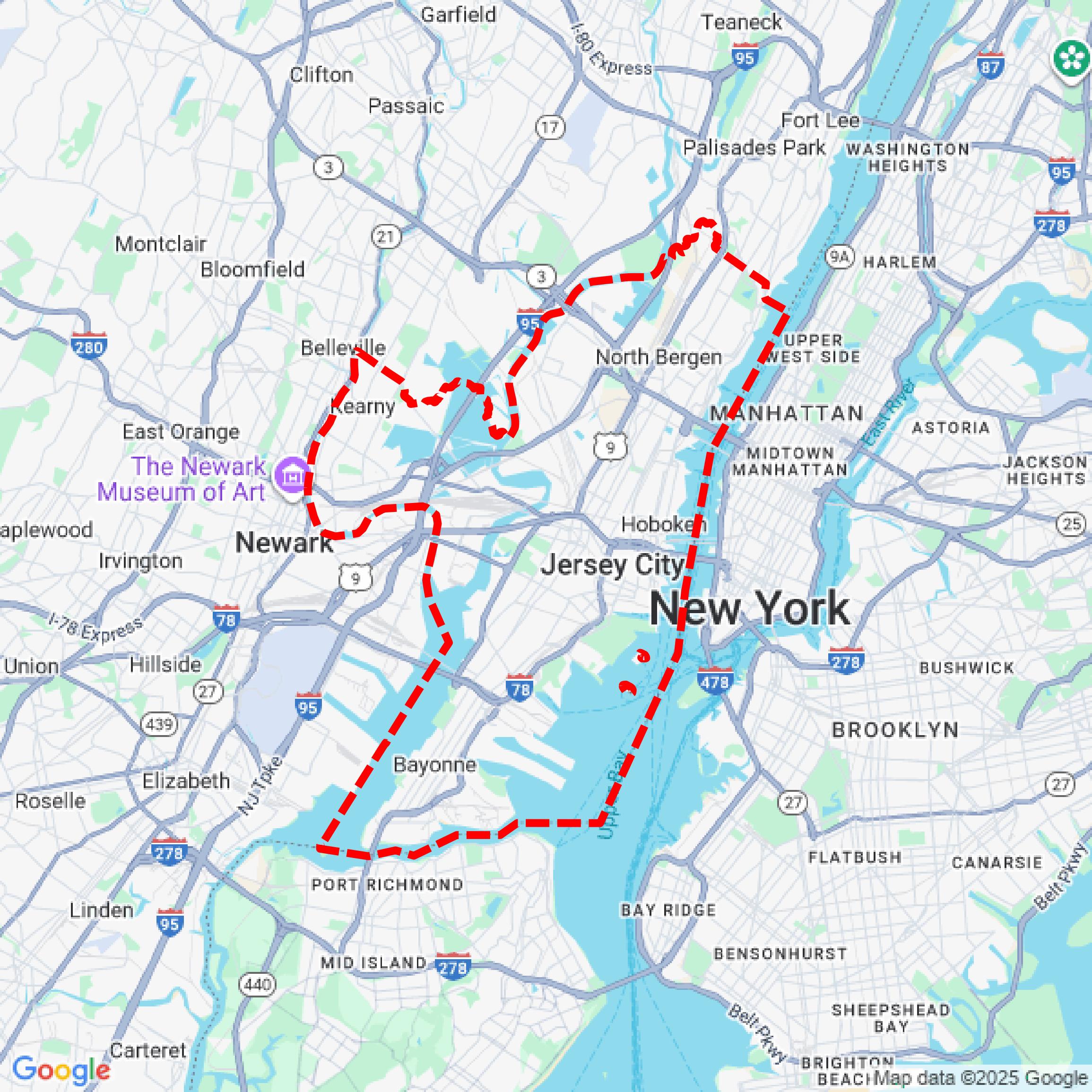

Data Available
Download GIS Data for Hudson County
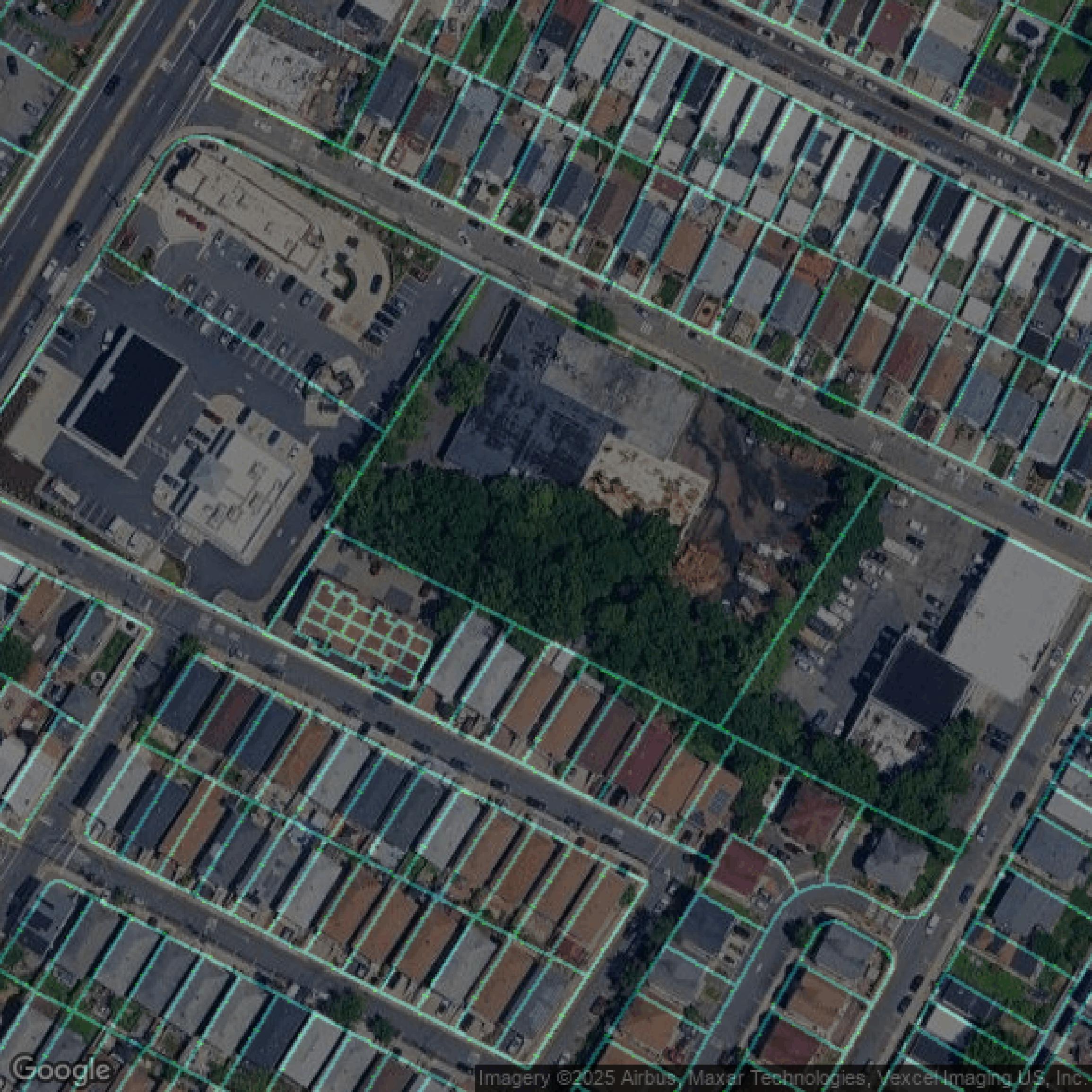
Parcels and Buildings
This image shows parcel and building data in Hudson County created using GIS data in Equator.
Get Parcels and Buildings for Hudson County
LiDAR
This image shows a LiDAR point cloud in Hudson County created using GIS data in Equator.
Get LiDAR for Hudson CountyContours
This image shows a contour map in Hudson County created using GIS data in Equator.
Get Contours for Hudson CountyFormats Available
Export Your Data Ready to Use in Multiple Formats
DWG
AutoCAD Drawing - Industry-standard CAD format
Supported Data:
Contour, Parcel, Building Outline
SHP
Shapefile - Standard GIS vector format
Supported Data:
Contour, Parcel, Building Outline
DXF
Drawing Exchange Format - Universal CAD interchange
Supported Data:
Contour, Building Outline
GeoJSON
Geographic JSON - Web-friendly spatial data format
Supported Data:
Contour, Parcel, Building Outline
LAZ
Compressed LAS - Efficient LiDAR point cloud format
Supported Data:
Point Cloud
SVG
Scalable Vector Graphics - Web vector format
Supported Data:
Contour, Building Outline
GPKG (Coming Soon)
GeoPackage - Modern OGC spatial database format
Supported Data:
Contour, Parcel, Building Outline
LandXML (Coming Soon)
Land XML - Civil engineering data exchange format
Supported Data:
Point Cloud
TIN (Coming Soon)
Triangulated Irregular Network - 3D surface model
Supported Data:
Point Cloud
XYZ (Coming Soon)
XYZ Point Cloud - Simple ASCII point cloud format
Supported Data:
Point Cloud
Background
GIS Data for Hudson County
The NJ Geographic Information Network (NJGIN) website offers a comprehensive suite of geospatial data and tools designed to serve professionals, researchers, and the public interested in New Jersey’s geographic information. Visitors can access the **Imagery Warehouse** app for downloading and streaming current and historical aerial imagery, including the fascinating **NJ Time Machine – 1930 and 2020 Imagery** to explore landscape changes over 90 years. Users can explore property information through the **Property Explorer App**, which allows searches of all NJ parcels by address, county, municipality, block, and lot. The site provides regularly updated core datasets such as **road centerlines, address points, and statewide geocoding service** with monthly updates starting June 2022. Elevation data, including **Quality level 2 elevation products** and detailed LiDAR collections from 2018 (Northwest NJ) and 2019 (South NJ), are available for download, along with point cloud data (.laz files). The platform supports data sharing with the public through **NJGIN Open Data!**, featuring recently shared datasets by NJOGIS. Users can also explore administrative boundaries with updated **Municipal, County, State, Legislative, and Congressional Districts** datasets and learn about boundary mapping history via the **NJ State Boundary Project Story Map**. Specialized tools like the **Congressional District Finder** help locate U.S. Senators and Representatives by address, enhancing civic engagement. Overall, NJGIN serves as a dynamic portal delivering authoritative, up-to-date geospatial resources and interactive applications for efficient spatial data exploration and analysis across New Jersey.
Access Hudson County GIS Data in Equator →Hudson County Portal →Showcase
Sample GIS Data for Hudson County
Parcels and Buildings
Parcel and building data in Hudson County are used in a variety of fields including architecture, real estate, and urban planning.
Get Parcels and Buildings for Hudson CountyLiDAR
Point clouds (LiDAR) in Hudson County can produce highly accurate 3D models of terrain, structures, and vegetation.
Get LiDAR for Hudson CountyContours
Contours in Hudson County visualize 3D elevations on a 2D surface allowing you to better understand your site.
Get Contours for Hudson CountyParcels and Buildings
Accessing Hudson County parcel and building data on Equator gives you access to coverage across the US.
Get Parcels and Buildings for Hudson CountyLiDAR
Hudson County LiDAR uses include land surveying, analyzing crop health, or even archaeological studies.
Get LiDAR for Hudson CountyContours
Hudson County contours can be used for construction & engineering, environmental science, and more.
Get Contours for Hudson CountyParcels and Buildings
Dozens of fields are contained within each Hudson County parcel and building data, including zoning, owners, and year built.
Get Parcels and Buildings for Hudson CountyLiDAR
Equator turns Hudson County LiDAR point clouds into various lidar-derived data sets, including DEMs.
Get LiDAR for Hudson CountyContours
Hudson County contours on Equator are produced from LiDAR coverage, allowing for high precision
Get Contours for Hudson County